

Hundreds of metres of flood walls could be built in Apperley Bridge under new plans submitted to Bradford Council, writes democracy reporter Chris Young.
Leeds City Council is working with the Environment Agency to plan major flood alleviation works along the River Aire as part of a £112 million pound project to reduce the risk of floods in the area.
The work will involve flood barriers, bridge strengthening and riverbank improvements across the Leeds/Bradford border, in Apperley Bridge.
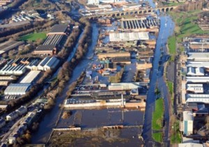
Just before Christmas, almost three years to the day of the 2015 floods that devastated parts of West Yorkshire including Kirkstall and Kirkstall Road, Leeds Council submitted a planning application to Bradford Council that would allow them to carry out the cross border works.
The application is for Phase 2 of the flood alleviation project, which starts in Apperley Bridge and includes new walls and embankments along the River Aire, with a temporary flood storage area at Calverley and riverside works down Kirkstall Road to Leeds city centre.
Work in Apperley Bridge includes the strengthening of the Grade II listed Apperley Lane bridge over the river.
Concrete flood defence walls will be built along the river in that area, including 240 metres of wall along Apperley Lane and around the Stansfield Arms and 620 metres of stone clad wall up to 1.8m high along Apperley Road.
A pavilion at Woodhouse Grove School will be replaced with a new pavilion made from “flood resilient materials” on a raised embankment.
On the bridge improvements, the application says there will be “replacement parapets and strengthening to the arches in the form of a concrete slab.”
A flood storage area will be created on the River Aire adjacent to the railway line at Calverley.
Referring to the Apperley Bridge plans, the application says:
“The businesses and residential properties within this area currently fall within Flood Zone 2 and Flood Zone 3. This means they have a medium and high probability of flooding respectively.
“The scheme proposes to increase the standard of protection to these properties and businesses to the same standard of protection as the rest of the scheme in Leeds i.e. to a 1 in 200 year flood event.”
It adds:
“The aspiration for Leeds Flood Alleviation Scheme is to reduce flood risk in areas of Leeds and Bradford whilst ensuring high-quality design and promoting accessibility.
“The design of the scheme carefully balances engineering requirements alongside urban realm design quality. Careful consideration has gone into the design of all structures and associated works to ensure that the Scheme is sympathetic to the historic landscape.”
A decision on the application is expected in March.
Kirkstall Road businesses and politicians came together before Christmas to call for the government to stop talking and start delivering the funding for vital flood defences.
Read more of the Dispatch‘s coverage on flood defences here.
______________
We encourage anyone living or working in West Leeds to use this website to tell their news. You can either use our Create an Article page, or e-mail us at news@westleedsdispatch.com.

